
Welcome to Finland! We hope that your OHFF park activation is fun and successful. Below are a few tips and requirements.
General
A CEPT license is sufficient for operating from Finland. From the mainland, the callsign structure is OH/homecall/P (no district number). In the Åland Islands, OH is replaced by OH0, and on Market Reef, by OJ0.
The general WWFF rules apply also in the OHFF program. In addition, based on rule 3.15 we require that your log file submission is accompanied by GPS-based evidence of your activation location. See more info on that below, under the heading “Location evidence”.
OHFF park access
Visits to Finland’s nature are governed by the concept of “everyone’s rights”. They grant free access to Finnish nature areas – including OHFF parks – regardless of land ownership, but the rights also come with some responsibilities and limitations.
For details, please see https://www.nationalparks.fi/everymansright. In OH0 there are minor additional limitations; please see https://www.regeringen.ax/miljo-natur/allemansratten and use the website’s translation function.
The OHFF hunter community wants to work you
The OHFF hunter community is very active on the low bands. If your radio setup allows you to work 40m and even 80m, many OH stations will be happy to work you on both SSB and CW – even in the middle of the day.
Finland is geographically “tall”, so if you are in northern Finland, 40m tends to work better on average, whereas 80m works better in southern Finland.
In addition to the WWFF cluster, you can self-spot to the OHFF hunter community by using a dedicated WhatsApp group (please contact ohff.coordinator@gmail.com for details on joining). You can also discuss your activation in the OHFF Facebook group.
How to find your OHFF park
Please see the OHFF map and choose a suitable park. Click on its icon and then click on the “Protected Planet” link to view the park borders (as per the WWFF rules, your full station should be inside the borders).
- After clicking the park icon, please note if the OHFF map displays a “Natura 2000”-type warning for your chosen park.
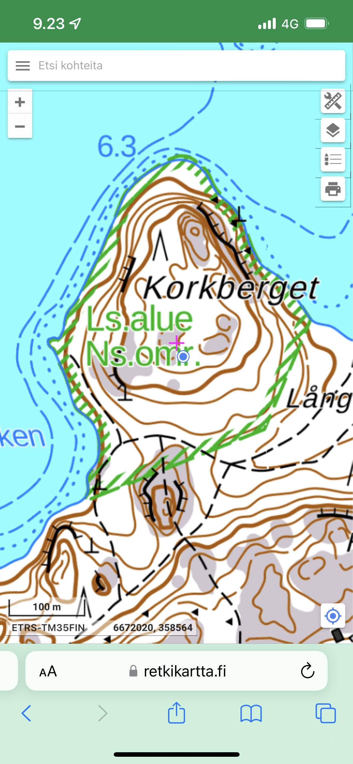
When you approach the planned QTH in nature, you can use https://www.retkikartta.fi or the “Tracker” app as a basic topographical map. They have integrated GPS functionality to help you.
- Please note that the “Retkikartta” website map shows the borders of traditional conservation areas, but not “Natura 2000”-type areas/parks. “Tracker” is able to show also those types of borders, when activated from the Kartat/Maps submenu.
Location evidence
The evidence consists of a simple image file, for example a mobile phone screenshot, that shows your QTH with a GPS dot on a suitable map background.
As noted above, use http://www.retkikartta.fi or the “Tracker” app as a topographical map background. Enable your phone’s GPS functionality and the GPS location feature on the chosen map. When the GPS dot appears and you’ve zoomed into a suitable range, use your phone’s functionality to save a screenshot.
If you don’t have mobile internet access while in Finland, you can instead use the “HamGPS” app to display and take a screenshot of your location.
Please see the image examples below for reference. From left to right, they show examples of http://www.retkikartta.fi, “Tracker” (both with GPS dots included), and “HamGPS”. This type of file must be included with your log submission.

Submitting your log and location evidence
Send your log and location evidence to ohff.finland “at” gmail.com as e-mail attachments. If you’ve activated several parks, please send a separate e-mail for each.
Name your ADI log file with the format “OH-SM1ABC-P @ OHFF-1234 20230822.ADI”. The name means that OH/SM1ABC/P activated OHFF-1234 on 22nd of August 2023.
Please ensure that your ADI log uses the MY_SIG and MY_SIG_INFO tags on every QSO line. MY_SIG should refer to WWFF and MY_SIG_INFO should refer to the relevant park reference code.
More information
If you need more information or are in doubt about something, please contact the OHFF coordinator OH6KZP, preferably before your activation, at ohff.coordinator@gmail.com.
